
GIS For Environment and Water Resources
Understanding the relationship between people and places is crucial for environmental officers, especially in the context of waste management.

GIS For Environment and Water Resources
GIS is an essential tool for mapping waste disposal sites, tracking waste collection routes, monitoring illegal dumping activities, and planning efficient waste management
systems.
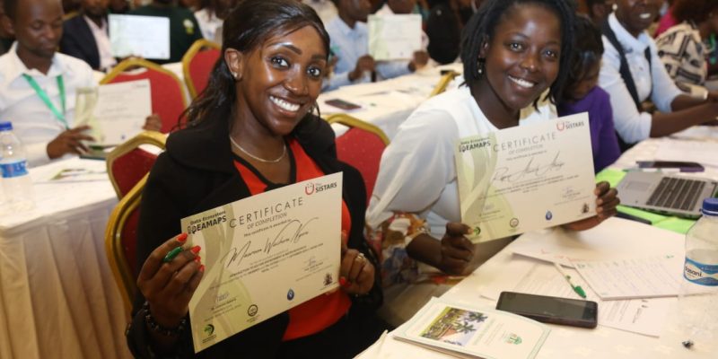
The SISTARS and Data Ecosystem IDEAMAPS projects flagged under African Population and Health Research Center (APHRC) have trained over 126 environmental officers. The
course focused on the fundamentals of GIS, including practical aspects of storing, analyzing, and visualizing spatial data.
During the training, special emphasis was placed on data collection techniques to ensure participants can gather accurate and reliable geospatial data.

Additionally, participants have learnt to use software such as QGIS and Data Wrapper.
Speaking during the graduation ceremony of the environmental officers, County Executive Committee Member for Green Nairobi Ms. Maureen Njeri, who also graced the occasion, noted that “Environmental department has made efforts to incorporate GIS in implementation of some of our sector objectives like geo-locating air quality monitors installed in different locations across Nairobi County that give air pollution levels in the real time by force. This has been instrumental in identifying air pollution hotspot subsequently informing policy decisions. It is our belief that working together with APHCR will greatly complement such achievements and fill existing gaps towards enhanced service delivery”
Prof. Faith Karanja who has been the Co-PI of The SISTARS projects says “There are many challenges that our city is facing. We have real issues to deal with water and environment in Nairobi. This training has been a quick win for our officers who are confronted with challenges of not knowing where the hotspots are i.e issues of waste management.”

GIS For Environment and Water Resources
1 in 4 African will live in slums by 2030. Currently, 1 billion people are estimated to live in slums and informal settlements worldwide.
Many of them are not visible in the
data used for policy and decision.
Dr. Caroline Kabaria says “IDEAMAPS Data Ecosystem is focused to co-create an integrated data ecosystem that enables routine, accurate mapping of slums, informal settlements, and other deprived areas across LMIC cities. (Pilot cities: Lagos, Kano (Nigeria) and Nairobi (Kenya)”
She adds “What we envision achieving together is improved data on “slums” and deprived areas across the city which needs to be updated regularly, improved data about assets and challenges at the community level.”
Nairobi Environment Chief Officer Mr. Geoffrey Mosiria lauded the trainers saying “I thank APHRC for the ability to provide guidance while fostering a collaborative environment, and I am looking forward to more collaborations and partnerships in future as we strive to make Nairobi county a better place to live and invest in.”

GIS For Environment and Water Resources
The just concluded GIS Training programme was designed to help the trainees use GIS to solve spatial related problems and challenges, in different sectors.


Comments